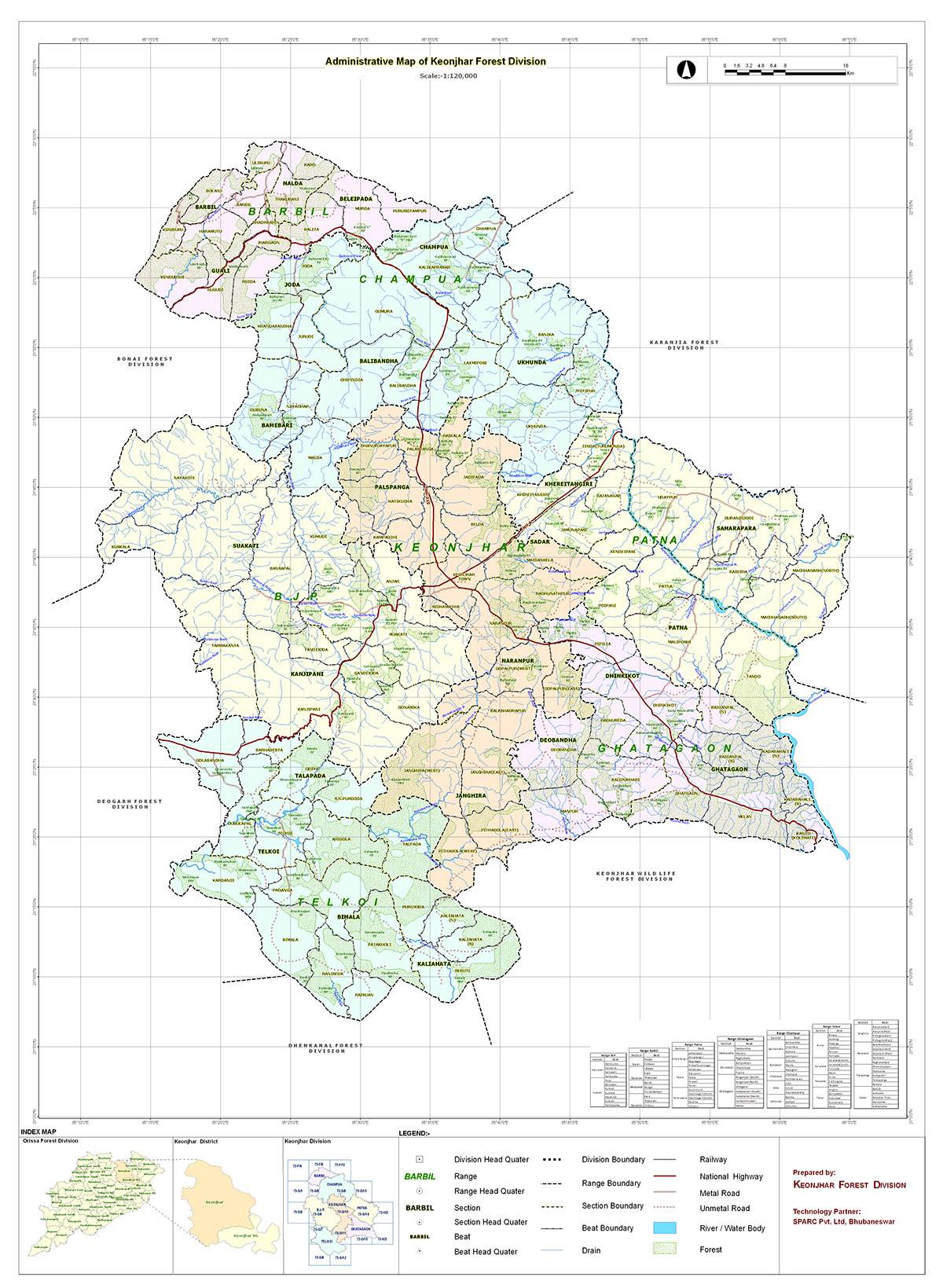
About Keonjhar Forest Division
Name and Situation
During British rule up to 1947, the forest areas covered under the working plan were part of the former princely state of Keonjhar, governed by the “Dewan” of Keonjhar under the former ruler. After Keonjhar merged with the province of Odisha in 1948, it was constituted as a district. After independence, the “Dewan” of Keonjhar managed forest growth by creating the Forest Department, headed by a Forest Officer, through a rule of accession. Since then, the Keonjhar Forest Division was created, encompassing the entire district of Keonjhar, with its headquarters at Keonjhargarh. The jurisdiction of the Keonjhar Forest Division is almost coterminous with the Keonjhar Civil Sub-division and the Champua Civil Sub-division of Keonjhar District, comprising 10 Tahasils and 10 CD blocks.
The undivided Keonjhar Forest Division continued to function until it was divided into two divisions—Keonjhar Division and Keonjhar (Wildlife) Division—as per Forest and Environment Department notification No. 1F (A)-99/2003/13214/F&E, dated 8th August 2003 (Annexure-I), with effect from 1st October 2003. The headquarters of the Keonjhar Division remained at Keonjhar (also called Kendujhargarh), while the headquarters of the Keonjhar (Wildlife) Division was established at Anandapur (Salapada).
The Keonjhar Forest Division lies between 21° 11’ N to 22° 16’ N latitude and 85° 18’ E to 86° 08’ E longitude, covering a geographical area of 6,268.56 sq. km.
Boundary of Keonjhar Division
Keonjhar Forest Division is bounded by Karanjia Division & Jharkhand State on North, Deogarh Forest Division & Dhenkanal Forest Division on South, Keonjhar (WL) Division, Anandapur on East & Bonai Forest Division on West. Keonjhar Division has its common boundary over 498.7 Km with four Territorial Division, one Wildlife Division and Jharkhand State.
Geographical Area
The geographical area of Keonjhar District is 8,303 sq. km. The district extends from the village of Bada Barbil in the north to the village of Jantia in the south, covering a length of about 150 km. It gradually widens and reaches a maximum width of about 70 km almost at the middle, i.e., from Binjabahal in the west to Turumunga in the east. The following setup shows the geographical area and forest areas of both divisions.
Configuration of the Ground
Eastern half of the district are the plains of Anandapur. To the west is a range of hills containing peaks such as Gandhamardan (3477 ft), Mankadnacha (3639 ft), Gonasika (3219 ft) and Thakurani (3003 ft).
The highlands consist of clusters of rugged crags and the mountaintops appear to be sharply ridged or peaked, however they have extensive tablelands on their summits. In some areas, isolated hills rise abruptly from the plains, but most areas have a general elevation of over 600m. The highlands form the watershed for a number of rivers, including the Baitarani River.
Nomira National Geological Monument
Pillow Lava in the iron ore belt at Nomira, located 2 km east of Nomira and 18 km south of Joda town on the Keonjhar-Barbil-Lahunipada State Highway, has been declared a National Geological Monument of India by the Geological Survey of India (GSI) for its protection, maintenance, promotion, and enhancement of geotourism. The Pillow Lava in the iron ore belt of Nomira is an exposure of ellipsoidal pillow lava with a maximum thickness of 2m × 0.6m. The fine- to medium-grained, green to bluish-green rock exhibits an abundant vesicular texture filled with quartz. The lavas, along with the associated pyroclastic rocks and tuffs, are underlain by quartzite and overlain by shale, chert-shale, and banded hematite jasper.
The site can be reached from Joda by following the Joda-Nayagarh road up to Bamebari and then taking a 2 km unmetalled road leading eastward to Nomira. The tract covered in this ongoing working plan has no sharp features to divide it into different physiographical zones. The entire tract is generally hilly and interspersed with winding strips of valleys. Keonjhar Division is distinctly divided into two parts, which are highly dissimilar in nature—lower Keonjhar and upper Keonjhar. Lower Keonjhar consists of Keonjhar valley and the lowlands of the Anandapur civil subdivision. Upper Keonjhar is mountainous and undulating, covering the Sadar (Keonjhar) and Champua Civil Sub-divisions.
Topography
Keonjhar Forest Division comprises a chain of mountains and hills along its western and southern borders, with distinct slopes towards the Baitarani River in the north and the Brahmani River in the south. The altitude of these hill ranges varies from 600m to 900m. The highest point in this division is Mankadanacha Peak (1,117.00 m MSL), which is located on the western border, overlapping the Koira Valley of the Bonai Forest Division.
Altitude of the hills
Sl. No. |
Name of the peak |
Height in meters |
|---|---|---|
1 |
Mankadanacha |
1117 |
2 |
Gandhamardan I |
1090 |
3 |
Gandhamardan II |
1062 |
4 |
Meghanad |
1054 |
5 |
Gonasika |
1009 |
6 |
Baliparbata |
990 |
7 |
Kajalpahar |
929 |
8 |
Thakurani |
918 |
9 |
Pithapidha |
916 |
10 |
Ranga Parbat |
897 |
11 |
Tankiahudi |
890 |
12 |
Kiriburu hill top |
883 |
13 |
Dahighar |
874 |
14 |
Suring |
834 |
15 |
Purunapani |
829 |
16 |
Siddhamath |
805 |
17 |
Mahaparbat |
721 |
18 |
Koili |
667 |
19 |
Sikheswari |
589 |
20 |
Sinduria |
511 |
21 |
Kalapahar |
463 |
River system
The district is mainly drained by the Baitarani River and its tributaries, except for a small patch in the extreme southwestern part, which falls within the Brahmani Basin. The major tributaries include the Kanjhari, Sitanadi, Salandi, Musal Nadi, Orarai Nadi, Remal, Kasai, and Deo Nadi, most of which are perennial. The drainage pattern is predominantly dendritic in nature, while a sub-parallel drainage pattern is well developed in the southeastern part of the district.
The drainage density is moderately high in the western part of the district, which consists of high hill ranges primarily composed of iron ore group rocks and volcanic formations, suggesting high runoff and low infiltration. Hydrogeological surveys and remote sensing studies have revealed that the drainage pattern in the district is controlled by a fracture system developed due to multiple phases of tectonic deformation in the area.
Geology, Rock and Soil
The geology of Keonjhar District is particularly interesting due to its mineral potential. It can be broadly divided into two distinct physiographic features: (i) The eastern alluvial plains of Anandapur and a portion of Sadar and Champua Sub-divisions, and (ii) The western mountainous terrain, consisting of lofty hills with intervening narrow valleys.
The area is densely forested and is characterized by high hills, notably Gandhamardan (1,090m MSL) and Mankadanacha (1,117m MSL).
Geology
- The occurrence of metamorphic patches belonging to older metamorphics of Archaean age.
- Huge batholiths of Singhbhum Granite with swarms of newer dolerite dykes in the eastern part of the district.
- A volcano-sedimentary sequence intruded by Bonai Granite, belonging to the Lower Bonai Group, with an age ranging from the Archaean to Palaeo-Proterozoic era in the southwest and northwest.
- Intrusives such as chromiferous ultramafics, gabbro-anorthosites, dolerite, and quartz veins of Archaean to Proterozoic age.
- Sedimentary and metasedimentary rocks belonging to the Kolhan Group, ranging in age from the Lower to Middle Proterozoic.
- Laterites of Cenozoic age.
- Quaternaries represented by the Kaimundi Formation and unclassified alluvium.
| Holocene | Alluvium | Kaimundi formation |
| Late Pleistocene to early Holocene | Clay with calcareous concretions | Kolhan Group |
| Cenozoic | Laterite and lateritic bauxite | |
| Palaeo to meso Proterozoic | Conglomerate, Sandstone & Shale | |
| Palaeo–Proterozoic | Danguaposi Lava | Kolhan Group |
| Proterozoic (undifferentiated) | Granophyres/Gabbro/Anorthosite/Norite | |
| Archaean Proterozoic | Newer Dolerite | |
| Ultramafic Rocks+ Chromite | ||
| Archaean to PalaeoProterozoic | Basalt Tuff, Metagabbro | Lower Bonai Group |
| Granite | ||
| Shale, Tuff, and Manganese | ||
| BHQ,BHJ, Ferruginous Shale and Quartzite | ||
| Gritty Sandstone, Ortho Quartzite & Conglomerate | ||
| Archaean | Hornblende schist, Cholorite schist, Amphibolite and Meta Gabbro | Gorumahisani Group |
| Quartzite, Quartz sericite schist, Cherty Quartzite, Fuchsite Quartzite and Black Chert | ||
| Quartzite, Chert | ||
| BHQ, BMQ, BCQ, BJQ | ||
| Ferruginous Shale, Carbonaceous Shale, Phyllite and Mica schist | ||
| Pebbly Quartzite, Gritty Quartzite and Quartzite | ||
| Singhbhum Granite/ Hornblende Granite | ||
| Politic schist, Quartzite, Amphibolite | Older Metamorphic Group |
Ecotourism Areas and Activities
Ecotourism is a form of tourism involving visiting fragile, pristine, and relatively undisturbed natural areas, intended as a low-impact and often small-scale alternative to standard commercial mass tourism. It means responsible travel to natural areas, conserving the environment, and improving the well-being of the local people. Its purpose is to educate the visitor, provide funds for ecological conservation, directly benefit the economic development and political empowerment of local communities, or foster respect for different cultures and human rights. Since the 1980s, ecotourism has been considered a critical endeavour by environmentalists so that future generations may experience destinations relatively untouched by human intervention. Several university programs use this description as the working definition of ecotourism.
Generally, ecotourism deals with interaction with biotic components of natural environments. Ecotourism focuses on socially responsible travel, personal growth, and environmental sustainability. Ecotourism typically involves travel to destinations where flora, fauna, and cultural heritage are the primary attractions. Ecotourism is intended to offer tourists an insight into the impact of human beings on the environment and to foster a greater appreciation of our natural habitats.
Responsible ecotourism programs include those that minimize the negative aspects of conventional tourism on the environment and enhance the cultural integrity of local people. Therefore, in addition to evaluating environmental and cultural factors, an integral part of ecotourism is the promotion of recycling, energy efficiency, water conservation, and the creation of economic opportunities for local communities. For these reasons, ecotourism often appeals to advocates of environmental and social responsibility.
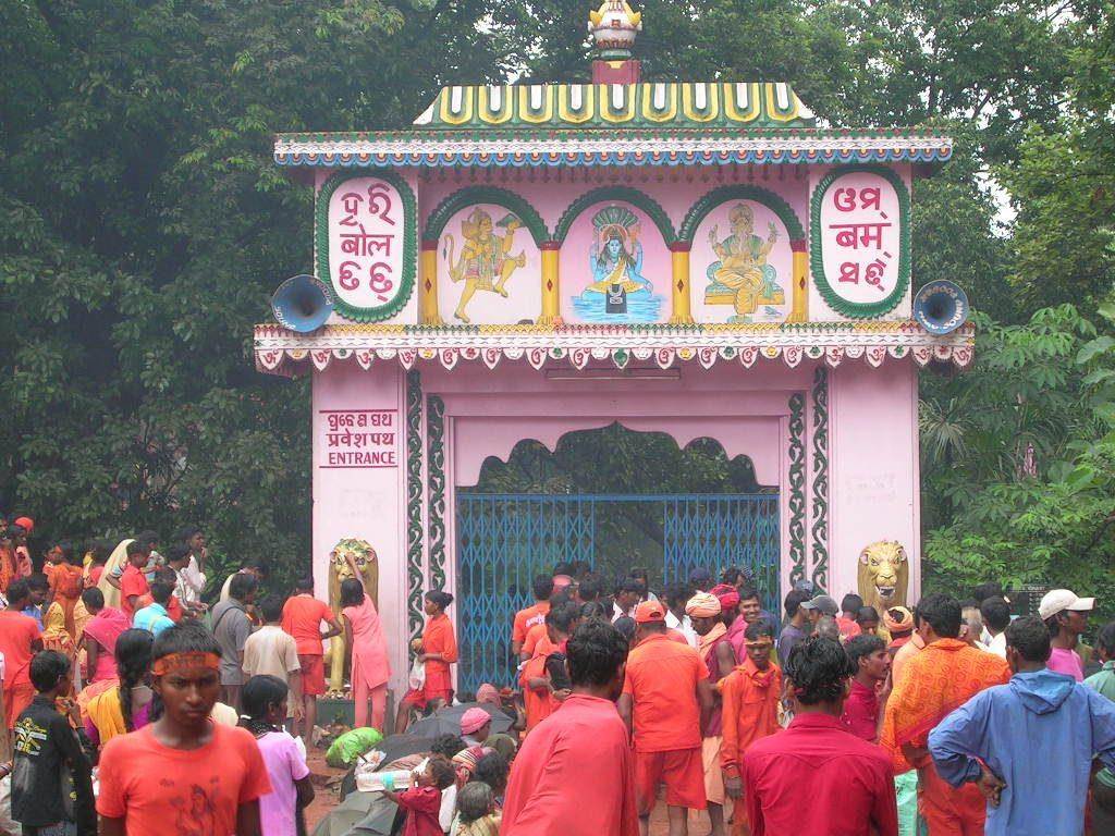
Development of ecotourism near the forest area has a great bearing on the conservation of forests and wildlife. In the present time, people love to visit forests. The Government of Odisha has also given more emphasis to the development of ecotourism near the forests. Beautiful cottages are being constructed, and local youths are being engaged for the maintenance of the ecotourism cottages and for providing delicious food to tourists. As a result, people are visiting ecotourism places and loving the forest and wildlife. Employment of rural youth is generated through ecotourism. The following ecotourism areas are identified in this Division adjoining the forest area.
Name of the range | Name of location having ecotourism potential. | Description of particular site with GPS reading | The natural attributes |
|---|---|---|---|
BJP | Anjar RF / Sana-Ghagara Waterfall, Machhakandana River | Sana Ghagara ecotourism complex, Anjar, is situated adjacent to Sana Ghagara Waterfall of Keonjhar District at an approximate distance of 5 km from Keonjhar District headquarters. N: 21°37’56.54” & E: 85°33’3.40” | Sana Ghagara Waterfall. The ecotourism complex flanks the verdant hill on one side, with the perennial flow of Machhakandana River and the forested landscape on the other side, marked by the presence of NH-49. The landscape of the site is unique and picturesque owing to undulated terrain and uniform Sal growth. Sighting of black bears and porcupines in summer is unique to the site. |
Apart from the above, more ecotourism spots can be developed in the division at Sitabinji, Bhimkund, Gonasika, Murga Mahadev, Khandadhar, Gundicha Ghagi, Handibhanga, Kanjipani Valley, Giridibandha, Kanjhari, Kulijhar Waterfall, Tenteinali Waterfall, Daragadasila scenic spot, and many more. All the spots are adjacent to forests and suitable as ecotourism sites for nature lovers.
The development will be undertaken following the provisions of the Forest (Conservation) Act, 1980, if so required.
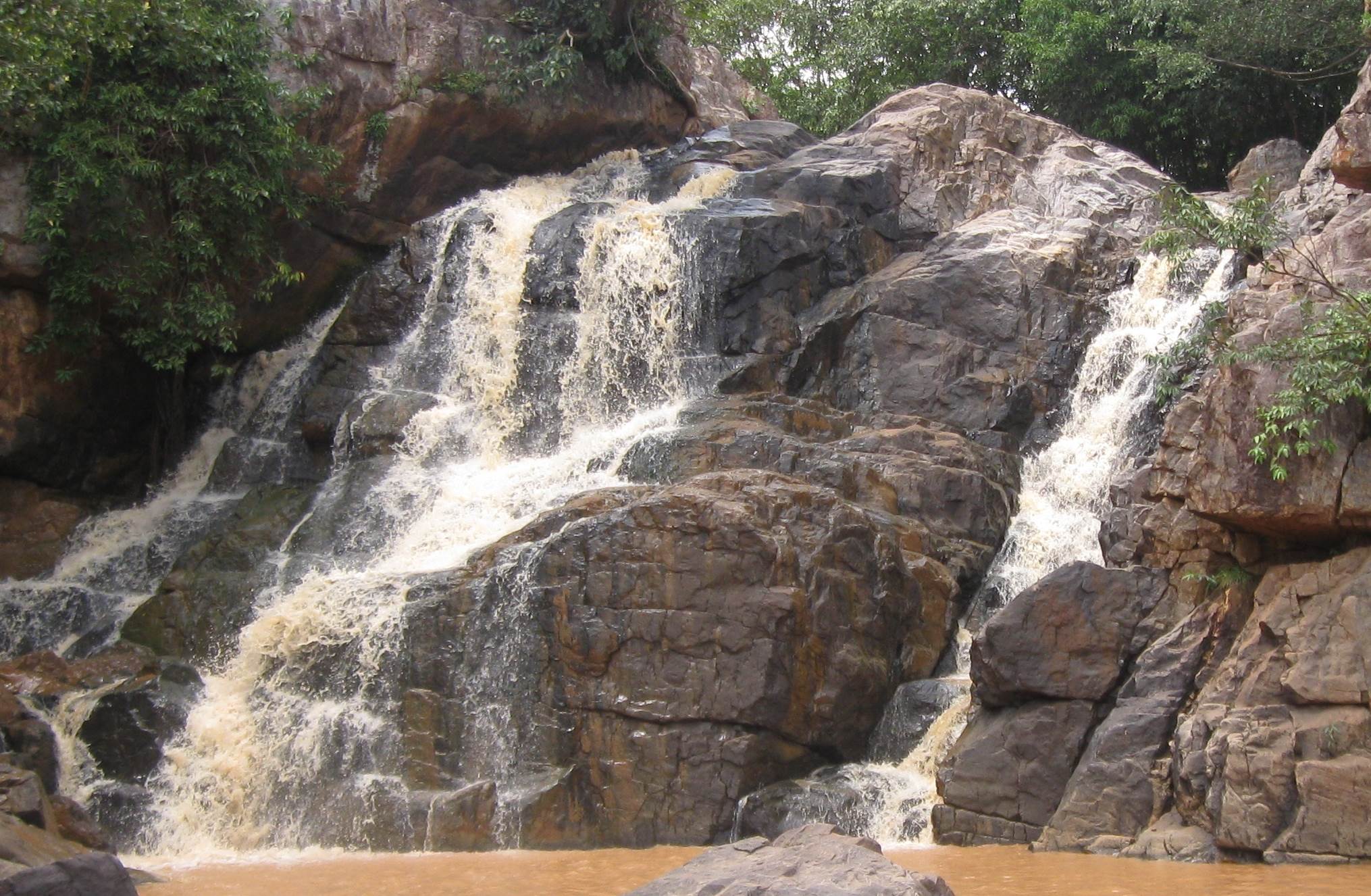
Bhimkund Waterfall
Bhimkund Waterfall, Keonjhar, has a stunning and spectacular natural environment encircled by lush green forest. The majestic Baitarani River provides two of the most beautiful and thrilling waterfalls, called Sanakunda and Badakunda, for nature lovers. The waterfall has a unique characteristic of offering an awe-inspiring experience to visitors due to its large vertical-shaped gorge and speeding current, which makes the environment misty. Furthermore, the huge roaring sound of the waterfall makes the place even more fascinating for tourists.
This waterfall is considered one of the most sacred places from a religious point of view. Local people gather here in large numbers during the annual celebration of Makar Sankranti. According to mythology, the Pandavas stayed here for some time during their religious expedition.
Gundichaghagi Waterfall
Gundichaghagi Waterfall is located amidst a spectacular natural environment with lush green forests. A cascade of waterfalls on the Musala River falls from a height of 50 feet below the river surface, making the area misty and attractive with its roaring sound. The waterfall looks like a silver garland. This picnic spot is truly a paradise for nature lovers, offering an unforgettable memory to visitors. The waterfall is just 12 km away from Ghatagaon.
Murga Mahadev Temple
Murga Mahadev Temple stands majestically at the foot of Thakurani Hills and is an important tourist spot in the district. A picturesque perennial spring from Thakurani Hills, surrounded by lush green forests, has gifted a gorgeous waterfall to nature lovers, which flows near the temple area, facilitating a holy bath for devotees. A huge crowd gathers here during Makar Sankranti and Shivaratri. This spot is just 70 km away from Keonjhar town.
Kanjipani Valley
Kanjipani Valley is a picturesque, panoramic natural spot with magnificent, up-rolling mountain ranges. The trail of Kanjipani Valley stretches over 20 km along NH-49, offering a unique experience to nature lovers at an altitude of over 610 meters. The place is a treasure trove of rich flora and fauna. During winter, the temperature drops to below 0°C, while clouds touch the valley during the rainy season, delighting tourists. This area is a haven of diverse flora and fauna, along with vast wildlife reserves. Driving smoothly on a circuitous route while overlooking the plateaus and tribal huts in the valley presents an uncommon beauty. It is just 30 km away from Keonjhar town.

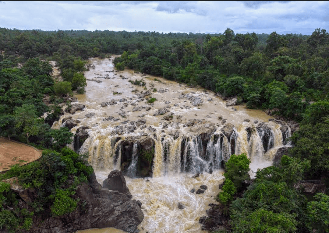
Sanaghagara Waterfall
Sanaghagara Waterfall is located in the Keonjhar district, about 3 km from Keonjhar town on National Highway No. 6 towards Sambalpur. The area spans over 488 hectares in a hilly terrain with characteristic mixed deciduous and miscellaneous forest vegetation. The famous Sanaghagara Waterfall, with its perennial stream, enhances the natural beauty of this forested region and attracts a large number of visitors throughout the year. It is situated at an average elevation of 1,950 ft above mean sea level (MSL) and experiences a relatively cool summer and a cold winter. The average annual rainfall is about 1,500 mm, and the temperature ranges from 14.7°C to 41.1°C. Relative humidity varies between 41% and 93%, and frost does not typically occur in this region. The area features highly undulating terrain with hills, pediments, and a narrow V-shaped valley. The hills and pediments are steep, with rock formations of dolerite origin. The area drains into the Baitarani River through the Machhakandana Nala.
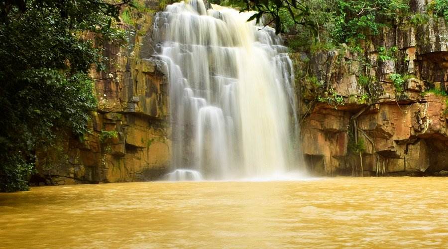
Badaghagara Waterfall
Badaghagara Waterfall, adjacent to Keonjhar town, is one of the most spectacular waterfalls, situated amidst a lush green forest. The waterfall stands at a height of 100 feet within a dense forest, offering a breathtaking experience to tourists, picnickers, and weekend holidaymakers alike.
The Badaghagara reservoir, constructed on the Machhakandana River during the kingdom era, serves as the primary source of water supply for Keonjhar town. The area is rich in exotic flora and fauna, making it a rare and valuable site for studying tribal life. This picturesque spot is just 10 km from Keonjhar town.